Museum of the Water Civilization in Morocco “Mohammed VI”, Marrakech

The Museum of the Water Civilization in Morocco “Mohammed VI” in Marrakech is one of the most fascinating cultural site in relation to the water and one of the unmissable places in Marrakech. Due to the richness of its architecture, its presentation and the message it conveys – Humans and water in Morocco, renewed genius and tradition – through installations, mock ups, new technology used, Historic reconstruction and above all the unique atmosphere in which the visitor is immersed, the AMAN Museum will make you travel through the hydraulic adventure and its challenge in Morocco and will reveal all about the water management in Morocco and the Moroccan genius in the Entrepreneurship of this wealth.

With a surface area of 2000 m2 spread out on 3 levels, the permanent exhibition welcomes you to experience a journey through the hydraulic epic in Morocco. An exceptional scenography exposing objects, models, maps, interactive games… with a spectacular 360° projection

Level 1: 1st floor
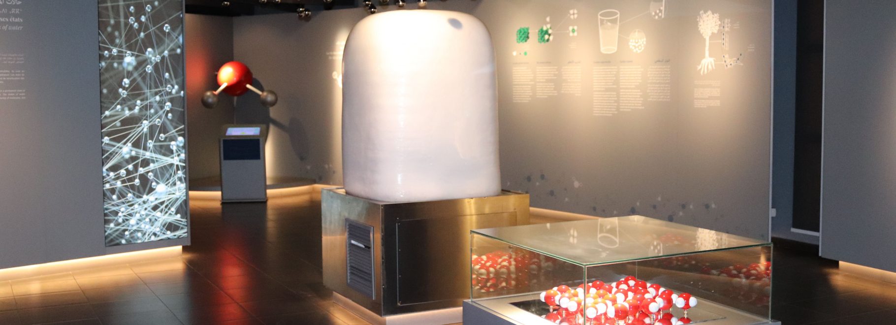
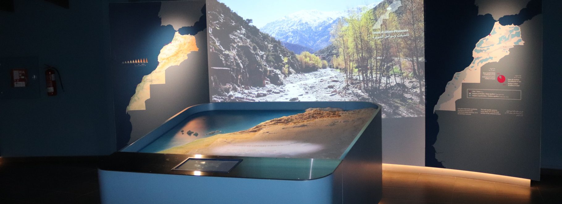
The first level of the museum highlights the scientific side of water, the geographical influence on the climate and water and also represents the common law applied in Morocco

Level 2: Ground floor
The second level is dedicated to oasis water management and to celebrations and rituals related to water
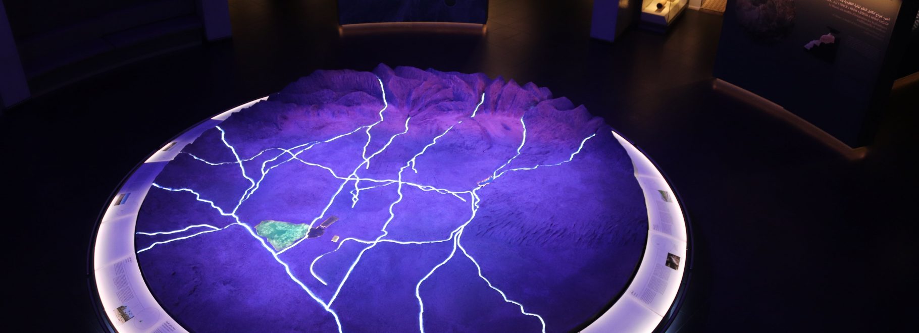
Level 3: Basement
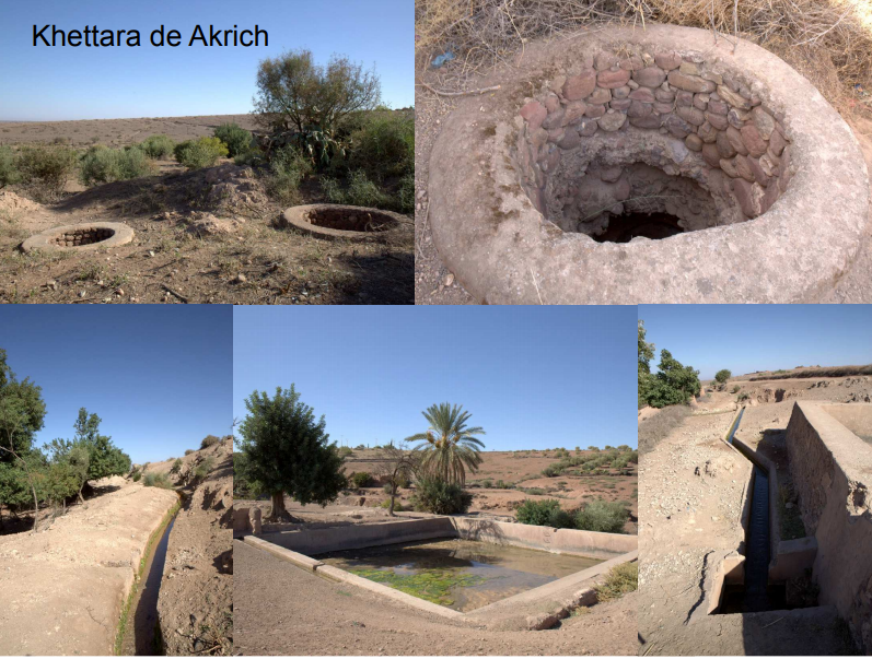
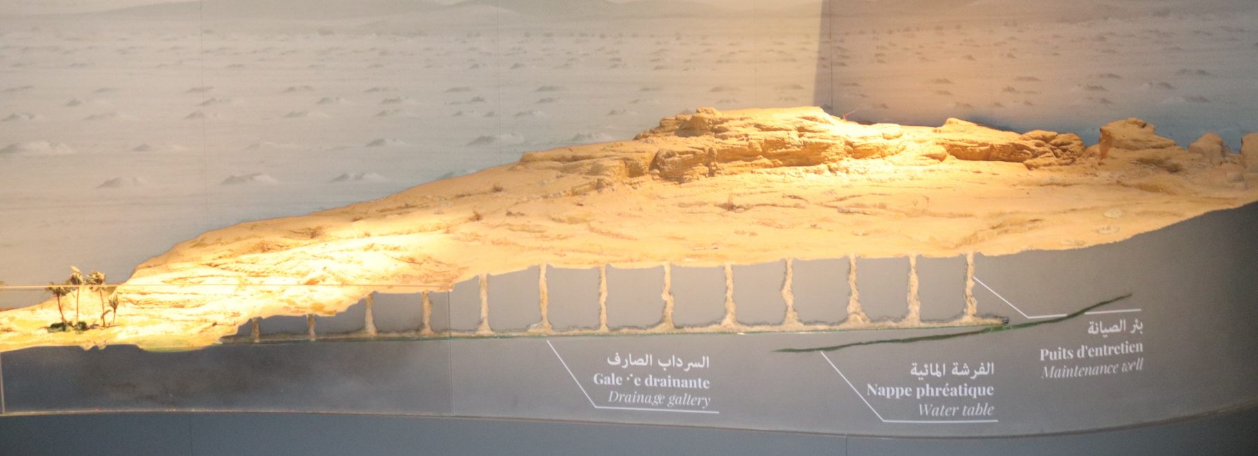
The 3rd level details the techniques of water abstraction, the water distribution and hydraulic revolution in Morocco. The last but not least, an impressive 360° video projections


Temporary Exhibitions

1. Temporary Exhibitions “Look on the palm of Marrakech”
The Museum Mohammed VI for the Civilization of Water in Morocco-Aman organizes a temporary exhibition under the theme “Look on the palm of Marrakech” by the photographer artist Mohamed Boussacsou from 30 March to 30 May 2019. The exhibition is the result of a long and meticulous work, which allowed the artist to grasp and reveal the aesthetics of the palm tree, through the cycle of seasons, from dawn to dusk. And now all the aesthetic manifestations of the palm reveal their secrets to the artist, revealing at the same time the relationships that the palm has with the light, the sky, the atmosphere and the degree of coloring of this tree with the shade. In addition to the aesthetic dimension, the exhibition captures the state of the palms, oscillating between beauty and misery. The exhibition challenges awareness of the danger that threatens this endangered natural heritage. Thus, the main purpose of this exhibition is to show the beauty of the palm tree, and to show its necessity in the eco-system of the oasis. On the visitor’s side, the exhibition aspires to educate the eye to look up, for better enjoyment of the horizon and to free the eye.

2. Temporary Exhibitions “Moroccan wildlife”
The Museum Mohammed VI for the Civilization of Water in Morocco-Aman invites you to discover the fauna of the kingdom “Moroccan wildlife” through the exhibition of the association of wildlife photographers of Morocco, between pure contemplation and vibrant advocacy. The exhibition will take place in the outdoor spaces of the museum, from 13 July to 13 September 2019. We aim, through this traveling exhibition, to show the splendor and beauty of Moroccan fauna through photos. This exhibition contains photos of birds, reptiles and mammals taken from all regions of Morocco by the members of our association (Moroccan Wildlife Photographers). By this action, we intend to encourage them to think about ways to preserve our rich natural heritage, which is extremely threatened by the human activities that represents a real danger for many animal species.

Itineraries

The Akrich khettara / Haouz

The itinerary is 35 km away from the museum. The Akrich Khettara is one the rare still in activity in Al Haouz, a region with 620 Khettaras, and a total of more than 700 km of galleries, which is why Marrakech was given its name, the town of hidden waters. The series of ventilation shafts of the Khettara, which are 50 to 100 m apart and about ten meters deep, lead to the outlet from which the water flows on the surface. A seguia channels the water to a first accumulation reservoir, before arriving in douar Akrich where it supplies the houses and herds with drinking water. From there, another seguia continues lower down to supply a second accumulation reservoir. The Douar Akrich Association for Development is responsible for the supervision and the maintenance of the Khettara. It struggles on a daily basis to protect the Khettara, particularly against the proliferation of wells with motors pumps, which threaten to lower the water table.

The Menara Gardens / Marrakech

Marrakech has been a green city since it was founded. The walled town had gardens like those still found in several large palace patios in the medina. But outside the walls, the sultans harnessed underground waters by digging out galleries (Khettaras), and made vast gardens irrigated by ponds collecting this water. Menara gardens, at the west of the town, were established by the Almohad Sultan Abdelmoumen Ben Ali Algoumi in the middle of the 12th century. They extend over 30 hectares, and are equipped with a water reservoir and large olive grove. The basin, which measures 150 meters wide and 200 meters long, is embellished by a pavilion that was built in the 16th century and renovated in 1870 by the Alaouite Sultan Moulay Abderrahmane, who stayed there in the summer. The gardens of Menara remain today a favorite spot for the local population and an ideal place for a relaxing stop near the bustling center of Marrakech.

The bridge of Tensift in the palm grove of Marrakech / Marrakech

Throughout the dynasties, the sultans set up the first infrastructures supplying water to the town and the plantations of Marrakech through dozens of local Khettaras. They added seguias bringing Atlas Mountains water from the rivers Ourika, Rirhaia and N’fis. They did not omit to create a major artery to link Marrakech to the north of Morocco. The Tensift River was a difficult obstacle to cross north of the town and young palm grove, as it collects all the flood waters from the High Central Atlas Mountains. The bridge with twenty-seven arches, the biggest of all the bridges on this river, was built in 1170 during the reign of the Almohad Sultan Abou Yacoub Youssef (1163-1184). For eight centuries, millions of people could access the across the town and leave freely, or leave the town and return safely. The construction of a modern bridge downstream of the medieval bridge ensured the preservation of this exceptional heritage.

Chrob ou chouf fountain / Marrakech

The art of fountains is an essential aspect of Moroccan hydraulic heritage. In particular, the medinas of Fes and Marrakech were equipped throughout the centuries with many fountains, which are masterpieces of decorative art. The different mosques of Marrakech had Khettara supplying the fountains used for ablutions and latrines, sometimes for hammams. The Almoravids koubba consists of three fountains for the Ali Ben Youssef mosque. Among the best known public fountains, Chrob ou Couf was created at the end of the 16th century under the Saadian dynasty. It is classed as a UNESCO heritage site, and its name means “drink and see”, which alludes to the Arabic “aïn”, meaning both eye and source. The disappearance of Khettaras led to the decline of public fountains, and only a few of fountains in the patios of the foundouq and the palaces, which are sometimes very ornate.

The Sidi Bou Othmane water cisterns / Haouz

The Sidi Bou Othmane hydro-agricultural complex was built by the Almohads during the 12th century to capture run-off water and channel it to large reservoirs to meet the needs of the army and caravans travelling north. The principle of this impluvium system is based on a catchment area leading to a decantation basin and nine cisterns with a total capacity of 3 254 m3. The cisterns are each 4 m wide, 5 m tall, and 25 m long, with several openings in the roof and are separated by 1.5 m thick wall. The archaeological site represents an example of Moroccan hydraulic ingenuity, bringing a sustainable water supply to an arid steppe. The galleries were decorated with very old ceramics, some of which are conserved in the El Badi Palace of Marrakech. The cisterns are still visible with their vault, but the inside is derelict. Near the site, there is a ruined dam, the upper part of which used to be equipped with seguia channeling water to the cisterns.

The elevation towers of Tamesloht / Haouz

Tamesloht plays a very important role in the hydraulic history of Marrakech as this religious foundation managed many property domains and controlled underground waters (Khettaras) and surface waters (seguias). Today, in this rapidly developing town, we can still see the impressive remains of several elevation towers, which were part of a very original water transfer system through a series of terracotta siphons. Water was transported through a Khettara from one side of the valley to the other so that there was a permanent water supply for watering a large garden. Instead of building a very costly aqueduct, the creator of this transfer imagined a siphon passing from one side to the other, but the order to limit the risks of bursting the pipes, he organized ten stations by installing transfer towers. Water passed from one tower to another until it flowed into a reservoir.

Ourika Valley / Haouz

Marrakech has its fountains and gardens but it is also privileged by the valleys near the High Atlas. The Ourika Valley is located 30 km south of Marrakech and has a well-established Amazigh population. The valley gradually rushes into the High Atlas. Its proximity to Marrakech makes it a great destination for a day trip that combines the discovery of spectacular nature with a traditional mountain lifestyle. The place is charming for a gourmet break by the river. The road slowly climbs the slopes of the Atlas, along the river Ourika and continues to Sett-Fatma, a popular village and a starting point for fabulous hikes. The most and relatively accessible is the one that leads to the seven waterfalls. The water management in the valley is an ancestral heritage and a common good in perched villages like Tizzi Noucheg on the North Slope. Seguias run along the mountainside and allow to carefully irrigate hundreds of hectares.

The itinerary is  23 km southern of Marrakech

Oukaïmeden peaks / Haouz

The site of Oukaïmeden is part of the chain of the High Atlas and is about 78 k by a good mountain road. It is home to the largest ski resort in the country, in the vicinity of a village with the same name. The ski area evolves between 2,500 and 3,200 meters above sea level. The resort is equipped with ski lifts, but skiers prefer to reach it on mule backs, which add to the charm of the site. The magnificent landscape of the summits of the Atlas reinforces the sensations of splendor and serenity that emerge from the site. For skiing, it is better to go from December to March to enjoy quality snow. If you decide to visit the region during the summer, you will enjoy exuberant nature and good old traditions related to water, especially the local agdal and the high-altitude pastures carefully managed by the peasant families of valley. You can also admire beautiful rock carvings that prove that Oukaïmeden was inhabited since prehistoric times.

Lalla Takerkoust dam / Haouz

The N’fis River has a considerable catchment basin. The masses of water from High Atlas were used for agricultural development and large seguias such as Tamesgleft, were set up on the left bank, or Targa Saada on the right bank (now an urbanized zone of Marrakech). A first dam was implanted in 1935 by the engineer CAVAGNAC to regulate the flow of the river, generating a vast conflict about dam water allocation between the Moroccan users of the ancient seguias and the European settlers. The dam was raised after Independence and renamed after the village of Lalla Takerkoust, where it was built. It allows for the distribution of water between the ancient seguias managed by water user associations, the low-pressure watering system managed by the Office of agricultural development by the Water Board (RADEEMA). Note that at the end of the summer, the level of lake is often very low.

The waste water treatment plant of Marrakech (STEP)

The treatment of waste water is an old problem in Marrakech, like in many towns throughout the world. For decades, the town had no solution to the problem, and gray and back waters were discharged into rivers and evacuated during flooding. In 2006, the STEP began to provide primary decantation treatment, then in 2008, secondary and tertiary treatment were set up (aeration, venting and clarification) in order to discharge sufficiently purified waters into the Tensift River. At the same time, sludge treatment is carried out by digesters and the methane gas is recovered to produce half of the electric consumption of the STEP. This novel system managed by the RADEEMA uses the purified waters to irrigate the many golf courses created in Marrakech since the beginning of the century.

Rocade Canal / Haouz

Since the 11th century, Al Haouz has been striving to guarantee its water supply with the means available at each period. There was the time when underground water was harnessed by 650 Khettaras (they were still being dug out in the 1950s), the epoch of 150 seguias, which are still in operation today drawing from the Ourika, Rirhaia or N’fis rivers, and finally the period of major hydraulic works initiated by His Late Majesty Hassan II among which there are Lalla Takerkoust dam and Rocade canal. The latter takes water from Lakhdar River and after 120 kilometers, it supplies the last hydraulic sector managed by the Office de Mise en Valeur Agricole du Haouz (ORMVAH). The management of the canal is automated from a control centre located in Hanout et Bakal, in the east of Marrakech. For professionals, it is possible to visit the whole installation with authorization from the ORMVAH. But some sections of the canal can be seen from public roads.

Ouzoud Falls

The Ouzoud Falls are located in the province of Azelal, 150 kilometers from the north-eastern region of Marrakech, Morocco, 80 kilometers from the town of Bani Mellal, the closest area to the large atlas village of Tangamelt, with waterfalls height about 110 meters. Located in the province of Azelal, Morocco, the site is the most visited in the area. Close to the green valleys, windmills, orchards and a wonderful circle of squirrels and the springs of the River Ebeid. These spectacular waterfalls, considered among the highest and most beautiful in Morocco, often dominated by a rainbow, are located in a wadi/ green rural valley of red sandstone, similar to an oasis, planted with olive groves, almond, fig and other carob trees, or a dozen small traditional oil mills are still in operation

Videos

SERs

Traditional hydraulic heritage

The Water Civilization in Morocco have a long tradition and a wide hydraulic heritage:

– Basins in traditional sehrij of Marrakech

– Irrigation canals and seguias in Middle Atlas tradition

– Noria in the tradition of Fes

– Fountain chrob ou chouf in Marrakech medina

– Metfia in the Atlantic plains tradition for collecting and reuse rainwater

– Water dispatcher in the oasis tradition

Ecological sanitation

The aim is to illustrate treatment technology and valorization of treated waste water as:

– Source separation of grey water and black water, with on-site treatment and re-use of byproducts for watering and fertilization

– A urine-diverting dry toilet (UDDT) with treatment of byproducts

– Anaerobic digester for black water treatment

– Planted filter to purify grey water

– Retention, catchment, ingress and use of rainwater.

– Islets and infiltration wells

– Cobblestones, draining

Good water modern practices

Integrated management of all park and museum waters; with No Net Loss :

– Drinking water

– Storm water

– Gray water (from sinks, showers, washing surfaces)

– Black water (from toilets and dishes)

– Treated water of water treatment plant in Marrakech

Gardens and farming traditions

The museum works on: Palm grove and oasis; Economical garden of water; Plant watering by buried crock pot; Market gardening; Ecological agriculture

Park project of Museum Mohammed VI of the civilization of water in Morocco

The park will cover an area of 3 hectares; it is a continuity of the museum beyond the walls and revitalization of Marrakech’s palm grove landscape. Its itinerary invites visitors to discover ancestral techniques of soil and water sustainable using, with living reproduction of hydraulic heritage. The park also represents demonstration site of modern sound ecological practices with educational approach. It gives pleasant walks across traditional gardens of Morocco and proposes range of services and leisure activities for adults and children.

School visit

Throughout the year, from October to June, the museum regularly receives school groups from various regions of Morocco, including the city of Marrakech and the Haouz region. 44% of our visitors are students; these visits, which are supervised by the museum’s teaching team in collaboration with the teachers, allow young visitors to explore the experience provided by the exhibition space, enrich their knowledge about the civilization of water in Morocco and make them discover the historical sites related to this element. Thereby, this will grant young people a state of readiness to inspect more closely the Moroccan hydraulic heritage, with its various aspects. Thus, more than 100 schools from urban and rural areas and all university institutions in Morocco introduce the museum as a spot and a place to visit in order develop knowledge about the civilization of water in Morocco and the engineering of our ancestors.

Educational Day

The Educational Day organized on 7th December 2019 at the Mohammed VI Museum of the Civilization of Water in Morocco (AMAN) is part of the week of COP 25. It was an opportunity to raise awareness and educate students about global warming issues, including water management.

This day took place in the form of a simulation of climate negotiations in 2 rounds, between 8 groups representing public and private high schools from the different regions of Morocco, as well as students from the University. Each group represented a country or geographical region and defended its position on the subject. These students were mentored by some 20 trainers.

During this simulation, the representative of the UN Secretary-General, appointed by the project group, took on the task of taking stock by a conclusion to announce the results at the end of the simulation.
The aim of the Ministry of Education and the AMAN Museum is to make water management an integral part of the education of children and young people in order to prepare them for a better world.

Trimble GPS installation

The purpose of installing this device is to perform the following measurements:

– changes in the level of the water table;

– the movement of the earth ;

– the humidity of the air around the museum.

Scientific research on water issue is now an essential choice for the museum.

By bringing together the expertise of the museum, national universities (such as Cadi Ayyad University, etc.), international universities (University of Barcelona, etc.), research centers and institutes (IRD, CNRST, GIZ), Watershed Agencies and Regional Agricultural Development Boards, The AMAN Museum is a federating framework ensuring the sharing of resources and synergy between these units or partners. With its content and qualified staff, it will therefore be a place of research and training where young researchers will find the opportunity to develop their skills and knowledge on water.

In this regard, the museum will:

– ensure multidisciplinary training and scientific research in the field of water through the proposal of research topics and the fulfillment of the projects;

– highlight and promote the hydraulic heritage in Morocco;
– enlarge the partnership between the museum and its socio-economic environment, namely in the field of water;

– strengthen and develop knowledge on water issue among our young researchers, as well as the initiatives related to the protection of ecosystems from pollution, the proper management and preservation of increasingly threatened water resources.